Friday, January 29, 2016

São Tomé and Príncipe


São Tomé and Príncipe are the two main islands in the volcanic archipelago that makes up the country of the same name. It is located in the Atlantic Ocean off the western coast of Africa. The closest country is Gabon. 95% of the population lives on São Tomé. The entire country has a population of roughly 190,428 (2014 estimate). The land area of all the islands is about 372 square miles, or roughly the size of the Raleigh-Cary metro region in North Carolina. The capital city is São Tomé, which is also the largest city. The official language is Portuguese, but other recognized official languages include Forro (a Portuguese creole),  Angolar (a creole spoken in Angola, and brought to São Tomé and Príncipe by Angolan slaves), and a few people, mainly on the island of Principé, speak Principense, another dialect of Portuguese-based creole. The principal religion is Catholicism left over from the colonial era, with a minorities of other Christian sects and Muslims. São Tomé and Príncipe became independent from Portugal in 1975.
Thought to be originally uninhabited, there was nobody living on these islands when discovered and colonized by the Portuguese in the 15th century. The first colonies were populated largely by "undesirables" from Portugal, mainly Jews. Originally the Portuguese set up vast plantations of sugar cane using slaves from the mainland, but soon competition from the West Indies made it unprofitable. After the sugar cane growing industry slowed in the 1700s, São Tomé e Principé became an important port in slave trafficking from mainland Africa to the New World. Coffee and cocoa were introduced as cash crops in the early 19th century, and they continue to be important to São Tomé and Príncipe's economy today, along with palm kernels (copra). Cocoa currently makes up 95% of São Tomé and Príncipe's agricultural exports. In the early 1990s, São Tomé and Príncipe was one of the first African nations to undergo democratic reform, holding their first democratic elections in 1991.
"São Tomé - Resort Pestana Equador" by jmaximo from Lisboa, Portugal - S. Tomé 1 110. Licensed under CC BY 2.0 via Commons
FUN FACT: São Tomé and Príncipe is the native habitat of the world's smallest ibis (Bostrychia bocagei), and the world's largest sunbird (Dreptes thomensis).


Thursday, January 28, 2016

Comoros


Comoros is a group of four volcanic islands in the Indian Ocean, about 200 miles off the coast of Mozambique. The capital is Moroni, and it has roughly 790,000 people. Comoros is 719 square miles in area, making it half the size of Rhode Island. The main religion is Sunni Islam, and the languages spoken are Comorian, Arabic, and French. Agriculture accounts for 50% of the GDP, and employs 80% of the labor force. The main exports are vanilla, ylang-ylang (an ingredient used in making essential oils) and cloves. 29% of the GDP comes from remittances of migrant workers abroad.

The earliest archeological discoveries on Comoros date back to the 4th century, but there is some speculation that the islands may have been inhabited as far back as the 1st century. The first inhabitants were Bantu speakers from Africa, and later Arabs and Austronesians settled there. Comoros became a French colony in the 19th century, and it remained so until independence in 1975. Of the islands comprising Comoros, Mayotte, is still under French administration, having voted against independence in 1975, when the rest of Comoros became independent.

FUN FACTS: Comoros is the world's largest producer of ylang-ylang, and second largest producer of vanilla.

some videos:
Daily Nabil
CNN on vanilla production in Comoros.

Tuesday, January 26, 2016

Tajikistan


Tajikistan is a land locked country in Asia that is roughly the size of Illinois. The main language is Tajik, which is very close to Persian, a remnant of the ancient Persian empire that ruled the region in the 6th century BCE until Alexander the Great conquered it in the 4th century BCE.  It was conquered by the Tibetan empire for a short time in the 600s and then by Arabs in the 700s, who converted the region to Islam. In later centuries, Tajikstan was under the control of the Mongol Empire, the Chagatai Khanate, then the Timurid dynasty, then later fell under the rule of Uzbeks and Afghans until it was claimed by Russia in the late 1800s. Throughout the latter half of the 20th century, it was part of the USSR. When the Soviet Union collapsed, Tajikistan became independent in 1992.


The capital city is Dushanbe, and the population is about 8,600,000. Over 90% of the country is mountainous. The main contributor to GDP is migrant workers sending wages home (usually from Russia), though there is also a lot of aluminum production and cotton farming.

Photo credit: Uncornered Market

FUN FACT: The unibrow is considered very beautiful on women, and those who are not born with one often use a herbal mixture to artificially create the semblance of one.

Photo credit: Destination 360

Monday, January 25, 2016

Swaziland


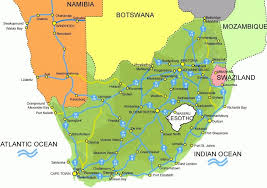
Swaziland is a country in Africa roughly the size of New Jersey. About 3/4 of it is bordered by South Africa on the north, south, and west (and a little bit on the east), and the remaining eastern border is with Mozambique.


The largest city and administrative capital of Swaziland is Mbabane, while the city of Lobamba is the legislative capital, and seat of the Parliament. The population is roughly 1,119,000, and it is an absolute monarchy. The king appoints 10/65 members of parliament as well as the Prime Minister. He can veto any legislation, as well as can make laws by decree.

Swaziland was formed when a number of Bantu clans broke away from the main tribe in the 1500s and settled in this area. They eventually united to formed a tribe in the 1800s to be stronger against their common enemy, the Zulu. Swaziland was a protectorate of South Africa in the 1880s, but then fell under English domain after the Boer war in the early 1900s. In 1969 it became fully independent.

Though Swaziland is a relatively small country, it has many geographic features, including mountains, flat plains, and rainforest. About 75% of the population are subsistence farmers, and the main exports are  soft drink concentrates, sugar, wood pulp, cotton yarn, refrigerators, citrus and canned fruit.

FUN FACT: Ngwenya Mine, the oldest mine in the world, is located in Swaziland. Stone Age people mined hematite to extract red ochre in this mine.

UN-FUN FACT: Swaziland has the highest incidence of HIV rates of adults in the world.


Thursday, January 7, 2016

Moldova

Moldova was one of the first countries to inspire me to do this project-- I was looking at a map several years ago and saw this little country, sandwiched between Romania and Ukraine and realized I had never ever even so much as heard of it. So, here goes.

MOLDOVA: population 3,538,288 (as of 2014). Capital city: Chișinău

Moldova is the poorest country in Europe, despite having a 99% literacy rate. The service sector is the largest employer, though there is a lot of agriculture and some manufacturing. Moldova is known for its wine making, and has historically been a major food supplier for Europe due to its awesome soil and temperate climate.

Moldova declared independence from the Soviet Union in 1991, and is a parliamentary republic. Most people are Orthodox Christians. The official language is Moldovan, which is pretty much the same thing as Romanian, though there are picky political nuances which dictate whether you call it Moldovan or Romanian. Moldovan was written using the Cyrillic alphabet until 1989, when the Romanian Latin alphabet was adopted.

Transnistria is a breakaway region on the eastern shore of Moldova's main river, the Dniester that stretches to the border with Ukraine. There was a brief civil war in 1992 over the region, and currently, though not recognized by the U.N., Moldova designates it as the Transnistria autonomous territorial unit with special legal status.


Fun Fact: Strong Drinks Museum, in Tirnauca village, is the largest building in the world in the shape of a bottle


Monday, January 4, 2016

Brunei

Brunei, officially known as the Nation of Brunei, the Abode of Peace, is located on the island of Borneo in the South China Sea. The rest of the island is occupied by Malaysia and Indonesia. Brunei is surrounded by Malaysia on the sides that are not coastline-- it is in two chunks that are separated by Malaysia. It's land size is roughly that of Delaware.

The capital is Bandar Seri Begawan, and the population is about 400,000.

Brunei is a constitutional sultanate that got its independence from the UK in 1984. It has lots of oil and natural gas, which make up its main industries. From the 13th-15th centuries, Brunei was allied with the Hindu Javanese Majapahit kingdom. As this kingdom declined, it became an independent sultanate  and Islam became widespread. From the 16th-19th centuries, Brunei was a powerful state, ruling much of Borneo and surrounding islands. In 1888, Britain established a protectorate over Brunei, which held until 1984, except for a brief occupation by Japan during WWII. The ruling monarch disbanded the parliament in 1984, making Brunei an absolute monarchy, but reinstated it in 2004 (although all the ministers are appointed by the sultan). In 2013, the government instated a 3-step plan for imposing shariah law on Muslims (and some laws that are applicable to non-Muslims)

Today, 3/4 of the population is Muslim Malay, while the rest is a mixture of mostly Chinese and indigenous people.

FUN FACT: Bruneians don’t point using their index fingers; this is considered impolite. They point with their thumbs instead.


Saturday, January 2, 2016

Suriname


I can roughly locate Suriname on a map (north eastern South America?), but don't know much about it. For example, I had no idea that the official language is Dutch (although Sranantongo, an English creole is a lingua franca, and at least 20 other languages are commonly spoken)! The capitol city is Paramaribo, and the population is about 573,000.

Suriname was inhabited by Arawak and Carib tribes until the British took over in the 1600s and started planting sugar. Then the Dutch took over. All this commerce was made possible by slavery. Numbers of slaves escaped from the plantations, and hung out with the tribes in the rainforest, even creating tribes of their own, these people are still called "Maroons.". Slavery was abolished in 1863, and as a result, workers were imported from Indonesia, China, and India. The culture is more Caribbean than South American, Suriname is a multicultural country, and no one ethnic group dominates.

Currently, tourism and agriculture are a big part of the economy, as is bauxite mining.

FUN FACT: Sephardic Jews have had a settlement in Suriname since the 1600s, when they were driven out of Europe. Suriname was one of the places they could go, and they ran a number of slave plantations. Currently, one of the only places in the world where you can find a synagogue next to a mosque is in Suriname.


Friday, January 1, 2016

Nauru

The first country I’m going to learn about is Nauru, simply because I’d never heard of it until I looked through a list of all the countries of the world.
Nauru is an island nation in the south Pacific, and has a population of around 10.000. The capital is Yaren.
It was settled by Polynesian & Micronesian people at least 3,000 years ago, but Europeans found it in the 1760s and called it Pleasant Island. In 1900, they discovered phosphate reserves, which were the result of prehistoric sea birds pooping, and from there proceeded to mine the crap out of it. The environment is currently all wrecked because of mining, and the unemployment rate is 90%. Though Nauru had one of the highest per capita GDPs in the 1950s, the economy went down the tubes in the 1980s because phosphate reserves were depleted, so for a few years in the 2000s, the economy was based on being a tax haven and money laundering place for Australians.
Bottom line: Beautiful tropical island messed up by colonialism.

FUN FACT: The native Nauruan language is not related to any other Micronesian languages.

Introduction!

Several years ago, I met a guy from Cyprus in line at the grocery store, and I realized I had no idea about anything Cyprus related (except the flag, which has the outline of the island on it). Then I was looking at a map of Europe and realized I had *never* heard of Moldova. My New Year's Resolution for 2016 is to learn something about every country in the world (and some of the non-country countries, like Greenland and Wales).