Congo is different from the Democratic Republic of the Congo, which used to be known as Zaire.
Congo (or the Republic of the Congo) is located in Central Africa. The capital is Brazzaville. The population is roughly 4,662,446, and it covers 132,047 square miles (roughly the size of new Mexico combined with Massachusetts, or slightly smaller than Germany).
The earliest inhabitants of Congo that we have record of are the Pygmy, who were displaced by Bantu speakers around 1500 B.C. In the late 1800s, the region became colonized by the French, eventually gaining independence in 1960. The government has been a little rocky since then, being under the control of communists until 1991, then had its first democratic elections. In 1997 there was a 4-month civil war, ending in a peace deal in 2003.
I did a report on Niger in 8th grade French class (we each had to report on a French colony), but honestly I don't remember anything about it except what the flag looks like, and I can point to it on a map within 2 countries... Over the years, I have had to point out to people that it is pronounced /nee JHER/ and not like the n* word.
Niger is a landlocked country in western Africa. It is 80% desert. The capital is Niamey, and the population is about 17,138,707. With a land area of 1,270,000 square km (789,141 sq miles), it is about the size of Texas, California, and Georgia combined. Although 80% of the population is Muslim, the separation of church and state is guaranteed in Niger's constitution.
Niger has been inhabited since prehistoric times. In the 5th century BCE, Niger was a hub in trans-Saharan trade. From 600–1591, the Songhai Empire was based in what was to become Niger. Over the following centuries, parts of Niger were controlled by the Hausa Empire, the Mali Empire, and the Kanem-Bornu Empire. In the early 20th Century, France tightened its grip on its African colonies, Niger included. After some bloody massacres, France had squashed most rebellions by 1922. Niger became independent from France in 1960.
Niger's main economic backbone is subsistence farming, though being a desert climate, only 11-15% of the land is arable. Niger also contains some of the world's largest deposits of uranium ore, which makes up its largest export.
Ténéré tree in 1961
Ténéré Tree monument
FUN FACT: The Tree of Ténéré was an acacia tree that stood 400 km from the next closest tree. It was known as "the Loneliest Tree in the World," and a famous landmark on trans-Saharan trade routes. It was knocked down by a drunk driver in 1973, and has been replaced by a statue.
UNFUN FACTS: Niger has both the world's highest fertility rate and the world's highest infant mortality rate.
the Dominica flag features the sisserou parrot, a bird found only on the island of Dominica.
Until this moment, I had no idea that Dominica was a different country from the Dominican Republic. Shows how much I need to do this project! I saw the flag once, which is really cool, and was wondering what country it was from. Now I know...
Dominica is an island nation on the Caribbean, one of the Lesser Antilles. The capital is Roseau, and the population is about 72,301.
Before colonization, the island was inhabited mainly by the Kalinago/Arawak people. Spain colonized Dominica, then France, then England. When the island was under French control, France imported a lot of African slaves, which became the majority population. The majority of the population is still of African descent today. Dominica became independent from Britain in 1978.
Due to Dominica's mountainous topography, European powers historically chose other islands with easier terrain to build ports and cities. Because of this, Dominica largely escaped the big resort culture of other islands. This led to Dominica being known as "The Nature Island of the Caribbean." Large swaths of pristine wilderness, coral reefs and beaches are protected from high-impact tourism in order to keep the island natural.
Boiling Lake, the second largest hot spring in the world
Dominica's economy has a rising banking industry, being a popular tax haven, but mainly relies on agriculture and eco-tourism. It's main agricultural export is bananas, and soap is its primary industrial export.
Eugenia Charles, first democratically elected black female head of state in the world.
FUN FACTS: The second woman head of state in the Caribbean was Mary Eugenia Charles, who was elected Prime Minister of Dominica in 1980. Charles was also the first democratically elected black female head of state in the world.
Slovenia has an area of 7,827 sq mi (roughly the size of Massachusetts). Most of the area is mountainous and/or forested. The main language is Slovene, which is a southern Slavic language. The capital city is Ljubljana, and the population is roughly 2,063,077.
Slovenia has been inhabited since prehistoric times. It was part of the Roman empire, Carolingian empire, recently the Austro-Hungarian empire and in the 20th century, joined with Serbia, Croatia, & Montenegro to become Yugoslavia. It became independent in 1991, and is part of the EU.
Bled, Slovenia
The main employment sector in Slovenia is service, employing around 2/3 of the population. The other 1/3 is in industry and construction. The main exports of Slovenia are automobiles, electronics, pharmaceuticals, and fuels.
When i went to get my car inspected last year, I was in the waiting room with a guy from Cyprus. He was impressed that I even had heard of the country! Basically all I knew, though, was that its flag is the only one in the world with a picture of the country on it, and that it was an island in the Mediterranean. I asked him what language they spoke there and he was like "good question!' He explained that most people spoke Greek, but it is a slightly different dialect than that spoken in Greece.
Cyprus is an island nation in the Mediterranean, which has inhabited since at least 10,000 BCE. It has an area of 3,572 square miles (slightly bigger than Lake Titicaca) and a population of about 1,141,166 people. The capital is Nicosia.
Due to Cyprus's strategic location in the Middle East, it has been occupied by many empires throughout its history, including the Greek, Egyptian, Assyrian, Persian, Byzantine, Arab Caliphates, Ottoman, and in the 20th Century, British. Cyprus became independent from Britain in 1960, and has been in dispute by Greek Cypriots who want to be part of Greece, and the Turkish Cypriots who wish to be part of Turkey. The island is partitioned, with the Turkish area under its own control. Turkey is the only nation to recognize this region as independent. The international community considers this region as part of Cyprus under Turkish occupation.
The main industries in Cyprus are tourism, shipping, and the financial sector. The main languages are Greek and Turkish.
FUN FACT: in Greek mythology, the goddess Aphrodite is said to have sprung from the sea near Cyprus after the titan Cronus cut off the god Uranus's 'nads and threw them into the ocean.
Bahrain is an archipelago in the Persian Gulf, off the eastern coast of Saudi Arabia. It occupies a total of 760 square kilometers, slightly smaller than Austin TX or the Isle of Man. The population is about 1,343,000, and the capital is Manama.
Bahrain was an important trading center of the Dilmun Civilization (ca. 4000-800 BCE). It was also famed for its pearl fisheries from this time until the 19th century. Oil was discovered in Bahrain in the 1930s, and benefitted greatly from the oil boom of the 1970s. Over the centuries, Bahrain was ruled by Assyrians, Babylonians, Persians and Greeks, until the region's conversion to Islam (one of the first places to do so). Bahrain was under Arab rule until the mid 19th century when the British seized it. Bahrain became independent in 1971.
Currently, Bahrain has a constitutional monarchy, though the king appoints all members of the upper house of parliament, and can dissolve the lower house at will. The king also appoints the prime minister and other ministers as well as commands the army. Women were given the right to vote and run for office in 2002.
Oil exports and banking are Bahrain's main source of revenue, with aluminum production and tourism important items as well. Bahrain's climate is mostly desert with little arable land, and because of this, it relies heavily on agricultural imports.
FUN FACT: Bahrain has 35 natural occurring islands in its archipelago, but has added 50 man-made islands to it.
East Timor is located on the eastern half of the island of Timor, which is part of Indonesia. The country also comprises two nearby island, plus an unconnected chunk of the western part of Timor island. The capital is Dili, and the population is around 1,201,542. East Timor's area is about 5,743 square miles, making it slightly larger than the state of Connecticut.
East Timor has had a long hard road to independence. It has been inhabited for at least 42,000 years, and was an important part of Asian trade networks before European colonization in the 17th century. Portugal colonized the eastern part of Timor in 1520, and nearly a century later, the Netherlands claimed the western part of the island of Timor as well as some surrounding islands. The fight over this island lasted until 1860, when Netherlands and Portugal signed a treaty dividing the island between the two countries.
During WWII, Japan occupied East Timor, resulting in the deaths of between 40,000 and 70,000 East Timorians. in 1949, the Netherlands gave up its colonies of the Dutch East Indies, creating the nation of Indonesia, which included West Timor. In 1975, Portugal gave up its colonies, including East Timor. Fearing Communist takeover, Indonesia invaded East Timor, occupying it until 1999. The USA and many western nations were supportive of this takeover, although the United Nations was not. The period of 1975-1999 was marked by Indonesia inflicting massive human rights violations on the people of East Timor. The U.N. deployed a peacekeeping force in 1999, which led to East Timor becoming independent in 2002.
About 80% of East Timorian households are engaged in agriculture, most of them subsistence farmers. However, some products, such as coffee, cinnamon, cocoa, and sandalwood are grown for export. There is oil off of East Timor's shores, whose revenue pays for nearly all of the government's annual budget, with very little going to the surrounding countryside.
São Tomé and Príncipe are the two main islands in the volcanic archipelago that makes up the country of the same name. It is located in the Atlantic Ocean off the western coast of Africa. The closest country is Gabon. 95% of the population lives on São Tomé. The entire country has a population of roughly 190,428 (2014 estimate). The land area of all the islands is about 372 square miles, or roughly the size of the Raleigh-Cary metro region in North Carolina. The capital city is São Tomé, which is also the largest city. The official language is Portuguese, but other recognized official languages include Forro (a Portuguese creole), Angolar (a creole spoken in Angola, and brought to São Tomé and Príncipe by Angolan slaves), and a few people, mainly on the island of Principé, speak Principense, another dialect of Portuguese-based creole. The principal religion is Catholicism left over from the colonial era, with a minorities of other Christian sects and Muslims. São Tomé and Príncipe became independent from Portugal in 1975.
Thought to be originally uninhabited, there was nobody living on these islands when discovered and colonized by the Portuguese in the 15th century. The first colonies were populated largely by "undesirables" from Portugal, mainly Jews. Originally the Portuguese set up vast plantations of sugar cane using slaves from the mainland, but soon competition from the West Indies made it unprofitable. After the sugar cane growing industry slowed in the 1700s, São Tomé e Principé became an important port in slave trafficking from mainland Africa to the New World. Coffee and cocoa were introduced as cash crops in the early 19th century, and they continue to be important to São Tomé and Príncipe's economy today, along with palm kernels (copra). Cocoa currently makes up 95% of São Tomé and Príncipe's agricultural exports. In the early 1990s, São Tomé and Príncipe was one of the first African nations to undergo democratic reform, holding their first democratic elections in 1991.
FUN FACT: São Tomé and Príncipe is the native habitat of the world's smallest ibis (Bostrychia bocagei), and the world's largest sunbird (Dreptes thomensis).
Comoros is a group of four volcanic islands in the Indian Ocean, about 200 miles off the coast of Mozambique. The capital is Moroni, and it has roughly 790,000 people. Comoros is 719 square miles in area, making it half the size of Rhode Island. The main religion is Sunni Islam, and the languages spoken are Comorian, Arabic, and French. Agriculture accounts for 50% of the GDP, and employs 80% of the labor force. The main exports are vanilla, ylang-ylang (an ingredient used in making essential oils) and cloves. 29% of the GDP comes from remittances of migrant workers abroad.
The earliest archeological discoveries on Comoros date back to the 4th century, but there is some speculation that the islands may have been inhabited as far back as the 1st century. The first inhabitants were Bantu speakers from Africa, and later Arabs and Austronesians settled there. Comoros became a French colony in the 19th century, and it remained so until independence in 1975. Of the islands comprising Comoros, Mayotte, is still under French administration, having voted against independence in 1975, when the rest of Comoros became independent.
FUN FACTS: Comoros is the world's largest producer of ylang-ylang, and second largest producer of vanilla.
Tajikistan is a land locked country in Asia that is roughly the size of Illinois. The main language is Tajik, which is very close to Persian, a remnant of the ancient Persian empire that ruled the region in the 6th century BCE until Alexander the Great conquered it in the 4th century BCE. It was conquered by the Tibetan empire for a short time in the 600s and then by Arabs in the 700s, who converted the region to Islam. In later centuries, Tajikstan was under the control of the Mongol Empire, the Chagatai Khanate, then the Timurid dynasty, then later fell under the rule of Uzbeks and Afghans until it was claimed by Russia in the late 1800s. Throughout the latter half of the 20th century, it was part of the USSR. When the Soviet Union collapsed, Tajikistan became independent in 1992.
The capital city is Dushanbe, and the population is about 8,600,000. Over 90% of the country is mountainous. The main contributor to GDP is migrant workers sending wages home (usually from Russia), though there is also a lot of aluminum production and cotton farming.
FUN FACT: The unibrow is considered very beautiful on women, and those who are not born with one often use a herbal mixture to artificially create the semblance of one.
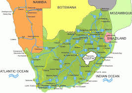
Swaziland is a country in Africa roughly the size of New Jersey. About 3/4 of it is bordered by South Africa on the north, south, and west (and a little bit on the east), and the remaining eastern border is with Mozambique.
The largest city and administrative capital of Swaziland is Mbabane, while the city of Lobamba is the legislative capital, and seat of the Parliament. The population is roughly 1,119,000, and it is an absolute monarchy. The king appoints 10/65 members of parliament as well as the Prime Minister. He can veto any legislation, as well as can make laws by decree.
Swaziland was formed when a number of Bantu clans broke away from the main tribe in the 1500s and settled in this area. They eventually united to formed a tribe in the 1800s to be stronger against their common enemy, the Zulu. Swaziland was a protectorate of South Africa in the 1880s, but then fell under English domain after the Boer war in the early 1900s. In 1969 it became fully independent.
Though Swaziland is a relatively small country, it has many geographic features, including mountains, flat plains, and rainforest. About 75% of the population are subsistence farmers, and the main exports are soft drink concentrates, sugar, wood pulp, cotton yarn, refrigerators, citrus and canned fruit.
FUN FACT: Ngwenya Mine, the oldest mine in the world, is located in Swaziland. Stone Age people mined hematite to extract red ochre in this mine.
UN-FUN FACT: Swaziland has the highest incidence of HIV rates of adults in the world.
Moldova was one of the first countries to inspire me to do this project-- I was looking at a map several years ago and saw this little country, sandwiched between Romania and Ukraine and realized I had never ever even so much as heard of it. So, here goes.
MOLDOVA: population 3,538,288 (as of 2014). Capital city: Chișinău
Moldova is the poorest country in Europe, despite having a 99% literacy rate. The service sector is the largest employer, though there is a lot of agriculture and some manufacturing. Moldova is known for its wine making, and has historically been a major food supplier for Europe due to its awesome soil and temperate climate.
Moldova declared independence from the Soviet Union in 1991, and is a parliamentary republic. Most people are Orthodox Christians. The official language is Moldovan, which is pretty much the same thing as Romanian, though there are picky political nuances which dictate whether you call it Moldovan or Romanian. Moldovan was written using the Cyrillic alphabet until 1989, when the Romanian Latin alphabet was adopted.
Transnistria is a breakaway region on the eastern shore of Moldova's main river, the Dniester that stretches to the border with Ukraine. There was a brief civil war in 1992 over the region, and currently, though not recognized by the U.N., Moldova designates it as the Transnistria autonomous territorial unit with special legal status.
Fun Fact: Strong Drinks Museum, in Tirnauca village, is the largest building in the world in the shape of a bottle